2007-06-24
 The Sony GPS-CS1 is a special-purpose GPS device that records a track log with position and time so you can geotag photos. There's no screen or output of any kind except for a few status lights, so you can't use the GPS-CS1 to tell where you are. I bought mine from Amazon for $93. (I got the GPSCS1KA package; there's also a similar package that costs $10 more and might have extra software for Sony cameras.)
You use the GPS-CS1 just like you use any GPS device to geotag photos: You turn the device on and leave it on while you shoot. Then you feed the GPS track log (which the GPS-CS1 and most other devices make available as a text file) and the photos into a tagging program which takes the time of each photo, finds that time in the track log, interpolates to calculate the position (lattitude, logitude, and elevation), and stores it as metadata in the photo itself. Once a photo is tagged, lots of applications and web sites can do various things with it, such as showing it on a map.
My own ImageIngester can geotag, and I've recently written here about some simple ways to display photos on a Google Map. (Click the Archives link, above.)
Most people are probably familiar with GPS devices these days as car navigation systems, but that kind of navigation isn't really a GPS technology. The GPS part of the device just determines its position. Another computer in the device shows it on a stored map and tells you when and where to turn based on a calculated route. Fancy navigation features are great to have, but they have nothing at all to do with geotagging photos. For that you just need the track log.
So, in theory, the Sony GPS-CS1 can do the job. In reality, it can't. Neither can another inexpensive GPS device I tried, a Magellan eXplorist 210 ($142).
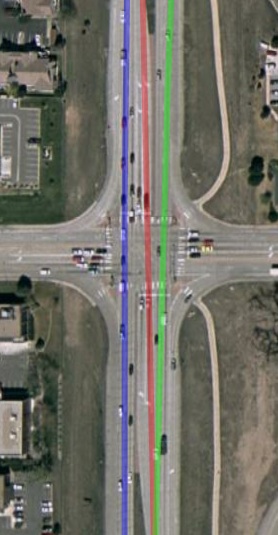
Yesterday I drove about 15 miles on roads with no tree cover, no tall buildings, and no nearby mountains. I put the Sony GPS-CS1 and the Magellan eXplorist 210 on the dashboard of my car, and a Garmin 60CSx ($357) on the center console, where it had a much less clear view of the sky. Then I took the three track logs and displayed them in Google Earth (an application for the Mac and other platforms, not the web site).
The results showed that the Garmin track followed the road, even the lane, exactly, and the other two were way off. One example is shown in the first diagram. The Garmin track is in blue, the Magellan in red, and the Sony in green. I was driving top to bottom in the picture, so the Garmin shows me driving on the right side of the road. The Magellan has me between the lanes, and the Sony has me in on the wrong side.
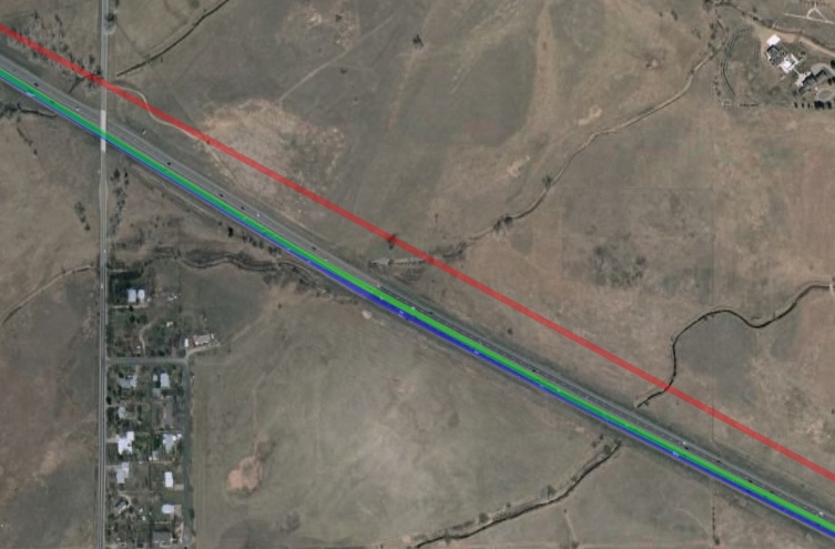
The Magellan isn't necessarily better than the Sony, as the next diagram shows, a bit later in the trip. This time the Sony was closer to the Garmin, and on the road, while the Magellan was way off.
Looking at the whole route, the Garmin was always on the road, and the other two were mostly in the wrong place. By "wrong place," I mean that the error was much greater than what the GPS system is capable of. If you want to tag your photos within one or two hundred feet of the actual position, then fine, but for lots of applications that's just too far off. Bear in mind that my conditions were nearly ideal. In a more urban setting the two cheaper devices would probably be even more wrong.
It's not that the Sony and the Magellan were always wrong. But such instruments need to be judged based on their reliability, and that's determined by when they're wrong, not when they're right. The Garmin was never wrong, not on my trip yesterday, nor on any other outing I've taken it on since I got it a few weeks ago.
For some results that confirm mine, look at the diagrams in this review. The writer says "This device does a great job of easily and automatically recording your location," but the diagrams he provides show that it actually does a lousy job compared to a better device he also tried.
It's not that Garmin knows something that Sony and Magellan don't. It's that the Garmin 60CSx has a SIRFstarIII GPS chip and the other two don't. I didn't run the test, but if I compared a $300+ SIRFstarIII-chip-based Magellan to a $150 Garmin without the chip, the results would show the higher-priced device to be right and the cheaper one to be wrong. Alas, the only attraction of the Sony is its low price, and that's just not enough to pay for electronics that actually work.
The Sony GPS-CS1 has a few other problems:
- It won't connect to a PowerPC-based Mac (even with OS X 10.4.10; I didn't try the as-yet-unreleased 10.5), although it works fine on an Intel-based Mac or on a Windows Vista PC. (I understand it also works fine on XP and Linux.) I have a lot of experience connecting USB drives to my Mac, and my guess is that it's not hard to make one that connects. Clearly, Sony just doesn't care. (Some reviewers blame the problem on Apple, but the PowerPC-based Macs have been around for years with no problems connecting to everyone else's USB devices.)
- Because the Sony has no display, you can't confirm that it's tracking. On devices with a screen, you can view the track to confirm that you've got it set up right. All you have on the Sony is a blinking light that tells you it's locked onto GPS satellites.
So, my advice for buying a GPS device for geotagging is to get a device with SIRFstarIII chip. Lots of photographers spend $2000 or more on their body and lenses, so why not $350 for the GPS? As as bonus, it will tell you how to get to the shoot and how to get home afterwards. If an accuracy of a few hundred feet is all you need and you don't use a PowerPC-based Mac, then the Sony GPS-CS1 is OK, and it does cost only $93.